
Overview
In 2014, the California Legislature and Governor passed the Sustainable Groundwater Management Act (SGMA) which encourages local agencies to take a leading role in managing their local groundwater resources. The intent of SGMA is to require sustainable groundwater management practices statewide, which will provide a buffer against drought and climate change.
The California Department of Water Resources (DWR) has prioritized all groundwater basins according to the following criteria established in the California Water Code Section 10933(b):
- The population overlying the basin,
- The rate of current and projected growth of the population overlying the basin,
- The number of public supply wells that draw from the basin,
- The total number of wells that draw from the basin,
- The irrigated acreage overlying the basin,
- The degree to which the overlying population rely on groundwater as their primary source of water,
- Documented impacts including overdraft, subsidence, saline intrusion, and other water quality degradation,
- Other information determined to be relevant by DWR, including adverse impacts on local habitat and local streamflows.
The possible rankings are very low, low, medium, and high. SGMA compliance requires that local agencies form Groundwater Sustainability Agencies (GSAs) for medium- and high-priority groundwater basins no later than June 30, 2017 and adopt a Groundwater Sustainability Plan (GSP) no later than January 31, 2022. The DWR Basin Prioritization Dashboard shows the results and scoring of all groundwater basins.
Groundwater Basins
Owens Valley Groundwater Basin is rated Low with 12.5 priority points according to the final 2019 prioritization based on the 2018 basin boundary modifications.
While OVGB is not considered adjudicated as a whole, Section 10720.8(c) of the California Water Code states that portions of OVGB managed according to the Inyo/Los Angeles Water Agreement shall be treated as adjudicated, and is therefore exempt from SGMA.
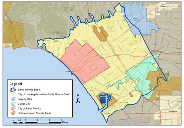
The Santa Monica Basin (DWR Basin 4-11.01) spans a surface area of 32,100 acres (50.2 square miles) in the coastal region of Los Angeles County. It is bordered by the Pacific Ocean on the west; the Inglewood fault on the east; impermeable rocks of the Santa Monica Mountains on the north; and the Ballona escarpment on the south. For more technical information on the Santa Monica Basin, please click on the Factsheet published by DWR.
As shown in Figure 1, the Santa Monica Basin underlies the Cities of Los Angeles, Santa Monica, Culver City, and Beverly Hills as well as portions of unincorporated LA County. In the City of Los Angeles, the Basin underlies Council Districts 5 and 11.
The Santa Monica Basin has been classified as a medium-priority basin by DWR and therefore must comply with SGMA through the formation of a Groundwater Sustainability Plan (GSP). LADWP has formed a GSA with the above-named agencies in order to provide continuous coverage over the entire Santa Monica Basin. The City of Santa Monica is the primary municipal producer of groundwater from the Santa Monica Basin; it is therefore serving as coordinating agency of the GSA and leading the effort in the development of the GSP. More information regarding the Santa Monica Basin Groundwater Sustainability Agency (SMBGSA) can be found on the City of Santa Monica GSA website.
Once a GSA has been formed, it is then responsible for creating a Groundwater Sustainability Plan (GSP) for the basin. Development of a GSP will be an iterative process where both technical and management evaluations are conducted and vetted through the stakeholders of the Groundwater Sustainability Agency (GSA). The workflow can be logically organized in tasks that align with the required elements set forth in the regulations. Tasks are evaluated in order, and work products are sequentially built into a plan for submittal to DWR. The GSP is required to address potential “undesirable results” in the basin and identify management strategies that mitigate and/or prevent undesirable results in the future. Six undesirable results are defined in the regulations as follows:
- Chronic lowering of groundwater levels (not including overdraft during a drought if a basin is otherwise managed).
- Significant and unreasonable reduction of groundwater storage.
- Significant and unreasonable seawater intrusion.
- Significant and unreasonable degraded water quality, including the migration of contaminant plumes that impair water supplies.
- Significant and unreasonable land subsidence that substantially interferes with surface land uses.
- Depletions of interconnected surface water that have significant and unreasonable adverse impacts on beneficial uses of the surface water.
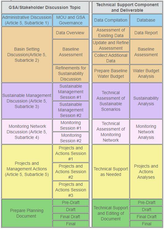
Figure 3 outlines this expected workflow for developing a GSP. The workflow is organized according the Article 5 of the GSP Regulations and shows a stakeholder engagement track that is supported by technical analysis. The GSP will progress sequentially from an initial administrative discussion through a basin setting discussion to set a technical “baseline”. Then, the GSA will work to define and defend sustainable management goals; apply those sustainability goals and criteria to potential management thresholds and actions; and develop a plan for implementing selected management actions. The number of stakeholder “sessions” necessary to work through various components of the GSP is not pre-defined, nor is the amount of technical support needed. This will depend on the number and complexity of the issues addressed in the GSP.
Public Participation
Santa Monica Basin
The City of Santa Monica, in coordination with partner agencies LADWP, Beverly Hills, Culver City, and LA County, are currently developing a GSP. As lead agency, the City of Santa Monica will continue to conduct public workshops to share progress and seek the input of the public during the course of its development. Meeting dates, agendas, minutes, and related documents can be found on the City of Santa Monica GSA website.
For more information
For more information regarding the Sustainable Groundwater Management Act, click on California Department of Water Resources.
-
Rafael Villegas (213) 367-1289
-
Rafael Villegas [email protected]