Here you'll find links to up-to-date information about current snow and precipitation conditions, snow course data, and the current year's runoff forecast.
Click on the links below to find information about why and how snow surveys are done, and the history of snow surveys in the Eastern Sierra.
Each winter, millions of people flock to the Eastern Sierra to enjoy the spectacular snow-covered mountains. The Eastern Sierra's abundant snowfall offers great downhill and cross-country skiing, snowboarding, snowmobiling, sledding, and many other winter activities. As winter gives way to spring, the melting snow supplies vital water flows that fill the many creeks and lakes in the area. The creeks and lakes provide habitat for fish and other wildlife, while offering countless outdoor summer recreation opportunities for visitors and residents alike.
Beyond its aesthetic and recreational appeal, the Eastern Sierra snowpack plays a vital role as the primary water source for more than 3.5 million City of Los Angeles residents. Approximately 65% of the City's water comes from Eastern Sierra surface water runoff. The rest of Los Angeles' water supply comes from the Colorado River, California's Central Valley, and groundwater sources within the Los Angeles city limits.
Because Los Angeles relies upon the Eastern Sierra for most of its water, accurate snow measurements are vital in order to forecast each year's water supply. Each winter, DWP hydrographic crews provide the data needed for forecasting by conducting snow surveys. By actually measuring the depth of snow and amount of water content in the snow at specific locations over a period of many years, forecasters can accurately predict the amount of runoff each year.
Many important decisions depend upon accurate water supply forecasting. The availability of water for irrigation needs, reservoir storage and operation, groundwater pumping levels, hydroelectric generation, maintenance programs, recreation availability and even the possible need for water rationing, all rely on accurate water supply forecasting.
Several times each winter, LADWP hydrographers trek far into the Eastern Sierra backcountry to survey the amount of snow that has fallen. The set out on skis, snowshoes, or in over-snow-vehicles called "snow cats," to measure the snow depth and amount of water content in the snow at specific mountain snow courses.
LADWP has measured the same 12 courses located in four major watershed basins since the 1920’s. The courses are located at varying elevations between 8,000 and 11,000 feet, and include the Cottonwood Lakes Basin, Big Pine Canyon, Rock Creek Canyon, and the Mammoth Lakes Basin. The sites were selected because they accurately represent overall snowpack and precipitation conditions at specific areas and elevations.
Preparations for snow surveys begin well before the snow falls. Big Pine and Cottonwood Canyon surveys require an overnight trip on skis and snowshoes, which means stashing sleeping and eating supplies in the backcountry. In September, LADWP hydrographers load provisions onto mules which are used to haul supplies to secluded cabins near the snow courses.
While in the backcountry, the hydrographers also perform maintenance work on the courses and calibrate snow sensor equipment.
LADWP hydrographers typically do their first snow surveys at the end of January. Surveys are also done at the end of February and March. For safety reasons, and because they often perform difficult work in severe conditions, snow surveyors travel in teams of two or three. All snow surveyors receive intensive training in snow sampling techniques, cross country travel, avalanche safety, first aid, and mountain survival.
Snow courses are marked using distinctive signs. A standard snow course is 1000 ft. long and has 10 measuring points. Hydrographers take a snow sample at each point and record snow depth and water content. These points are then averaged, and an overall water content is determined and recorded for that course.
Snow samples are collected by using a "snow sampling set" consisting of a series of aluminum tubes about 1.5 inches in diameter and 30 inches long that can be screwed together. Hydrographers screw enough tubes together to reach from several feet above the snow surface all the way down through the snowpack to the ground. The bottom tube has a sharpened steel cutter to slice through ice layers in the snowpack.
The hydrographers weigh the long empty tubes that have been attached together to establish their base weight, and then push them down through the snowpack until they reach the ground surface. Graduations etched on the side of the tubes indicate the depth of the snow, which the hydrographers record. The tubes are then raised out of the snow. Slots cut into the tube allow the hydrographers to visually verify that all of the snow core remained in the tubes as they were being raised. They then check the bottom of the tubes for signs that ground level was actually reached, such as dirt and other debris.
The tubes and snow core are then weighed. The hydrographers then determine the snow water content by subtracting the weight of the empty tubes, and record the data. They then dump the snow core out of tubes and move to the next sample point. Depending on weather and snow conditions, up to three courses can normally be done each day.
Mammoth Mountain Ski Area President Dave McCoy (right, with an unidentified co-worker) started as a LADWP Hydrographer in the 1930's.
Snow surveying, or the measuring of snow depths to determine spring and summer water runoff, began in California’s Sierra Nevada mountain range in 1906 with the work of Dr. James Church of the University of Nevada at Reno. Dr. Church began measuring snow on Mount Rose, just east of Lake Tahoe, to study the relationship between the amount of snow on the ground and runoff.
In 1910, the first permanent snow courses as we now know them were set up and measured in the Tahoe Basin. Hydrographers placed markers on the ground at specific locations and returned on a regular basis to measure the amount of snow at the site, and the water content in the snow.
Dr. Church's measurements helped put an end to battles between land owners surrounding Lake Tahoe and downstream water uses by predicting spring runoff so that water releases could be regulated to prevent both flooding and the waste of water. His pioneering work in snow hydrology continues to be the foundation for water supply forecasting today.
Hydrographers from the LADWP visited Dr. Church in 1925 to learn his techniques. Taking what they had learned, LADWP crews established snow courses and began regular snow surveys in 1926 at four Eastern Sierra basins: Cottonwood Canyon, Big Pine Canyon, Rock Creek, and Mammoth Pass. Today, these four locations continue to provide valuable data used by LADWP runoff forecasters.
In 1929, the California State Legislature, after seeking input from the major water providers in the state, enacted legislation that formed the California Cooperative Snow Survey Program (CCSSP). This established a coordinated and centralized snow survey program to provide information for water users across the state. By 1929, there were already 50 snow courses around the state being measured on a regular basis. Most of these courses were located in the Eastern Sierra and provided data for flow into Lake Tahoe and the Mono Lake and Owens River Basins. The CCSSP now has 40 members and measures more than 280 courses throughout California.
In the the early years of snow surveying, hydrographers traveled to survey sites using a variety of methods including snowshoes, nine-foot wooden skis, and even dogsled teams. More recent times have seen travel by snow-cats, snowmobiles, and even helicopters. However, hydrographers continue to rely on snowshoes and skis to get the job done. And the main part of the work still involves long days in conditions that vary from intense snowstorms to hot sunshine, and can even mean spending a night out in the backcountry.
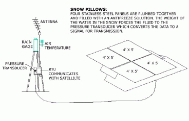
Beginning in 1971 and continuing to the late 80's, the LADWP, in cooperation with the State of California, began developing a system to collect snow data from the backcountry without people having to visit far-off sites. Over the years, a number of telemetry sites have been installed that now provide data that is updated automatically several times a day, and relay it to a central information collection location.
Mattress-sized "pillows" filled with an antifreeze-type liquid have been installed at snow survey sites. The weight of snow falling on the pillows displaces the liquid in the pillows, producing a data signal that is transmitted to the California Department of Water Resources in Sacramento via telephone line, radio, or even satellite. Data collected includes water content of the snowpack, temperature, wind, and solar radiation. While the data is only considered preliminary until it is verified by hydrographers doing a snow survey, it is accessible over the Internet.
Although this system is still in the development stages, it provides valuable data used to determine trends in the snowpack. Tests are currently being conducted throughout the west with the hope of finding a more reliable instrument for monitoring water content in the snowpack. Until that time, the backbone of the snow survey program remains the "snow surveyor" who measures the snow by hand, just like it was done almost 100 years ago.