
Proposed Alignment Map
Background
LADWP is continually assessing the existing electric grid to provide reliable power to residents and businesses in the city. A key feature of the grid is a high-voltage direct current transmission system, known as the Pacific Direct Current Intertie (PDCI), which transmits bulk power between the Pacific Northwest and the Los Angeles area. The energy transmitted via the PDCI to Southern California is generated primarily by hydroelectric and wind power facilities. The system has a capacity of 3,100 megawatts (MW), which is enough power to serve 3 million homes. The capacity is shared among the PDCI partners, which are Bonneville Power Administration, LADWP, Southern California Edison, and the cities of Burbank, Glendale, and Pasadena. LADWP is the operating agency for the southern portion of the system.
An integral part of the PDCI is the Sylmar Ground Return System, which ensures power reliability. While needed infrequently, the system is designed to carry current when the PDCI is experiencing an anomaly. The system allows unaffected portions of the PDCI line to continue providing power in the event of an interruption and also ensures a consistent flow of electricity along the line during normal operations.
Existing Ground Return System
The Sylmar Ground Return System includes 31 miles of overhead lines, underground cables, and underwater cable segments that begin at the Sylmar Converter Station, the southern terminus of the PDCI.
The existing overhead line extends from the Sylmar Converter Station to the Kenter Canyon Terminal Tower, north of Sunset Boulevard. From that point, the overhead line transitions to an underground cable. The underground portion travels along portions of San Vicente and Sunset Boulevards, briefly crosses through the City of Santa Monica, and terminates near Sunset Boulevard and Pacific Coast Highway. It continues on the ocean floor for approximately 6,000 feet offshore, ultimately connecting to an electrode array. The electrode array provides a “ground point” at which the electric current can travel through the earth.
Project Benefits
The major benefit of replacing the Sylmar Ground Return System is to ensure that the PDCI continues to operate reliably. The existing Ground Return System has not been upgraded since the original PDCI was first energized in 1970, even though the PDCI itself has been upgraded several times. The project will help to:
- Maintain the reliability and stability of the power generation and delivery system for Southern California;
- Continue to meet current and projected demand for power; and
- Increase the available share of renewable resource energy from wind power in the Pacific Northwest.
Project Location
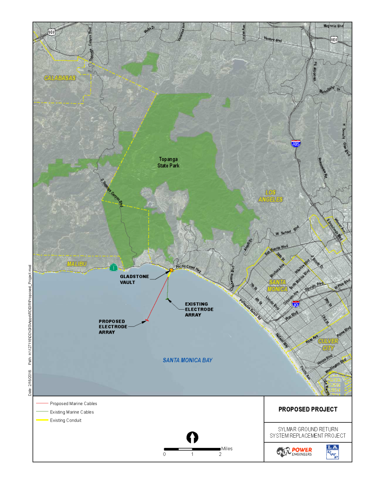
The proposed Project would be located primarily in Santa Monica Bay but would also include a small landside portion located in an existing parking lot on the south side of Pacific Coast Highway (PCH) at Sunset Boulevard, where the existing Gladstone Vault is located. The Gladstone Vault is the termination point of the existing underground segment of the Sylmar Ground Return System (SGRS). The proposed SGRS marine cables would extend from the Gladstone Vault beneath Will Rogers State Beach and under the ocean floor to the proposed electrode array located in the Santa Monica Bay, approximately two miles offshore.
Project Description
LADWP is proposing to replace the existing marine cables and the marine electrode portions of the SGRS. The replacement facility will be located in the vicinity of the existing SGRS marine facility in Santa Monica Bay. While the new marine facility would be in a different alignment than the existing, it would serve the same purpose and function as the existing facility.
From the Gladstone Vault, the new marine cables would extend to a new electrode array in the Santa Monica Bay. The marine cables would be installed several feet beneath the ocean floor to approximately two miles offshore where the new electrode array would be located on the ocean floor at a depth of approximately 100 feet below mean sea level. The array would be composed of 36 concrete vaults, arranged in two rows of 18 vaults, resting directly on the ocean floor.
Environmental Impact Report
As the Lead Agency under the California Environmental Quality Act (CEQA), LADWP is required to prepare an Environmental Impact Report (EIR) for the proposed project. The Draft EIR provides a detailed evaluation of potential impacts related to air quality and greenhouse gases, biological resources, cultural and paleontological resources, noise, traffic, and marine resources.
Public Review
The previous Draft EIR was circulated for a 45-day public review period, in late spring/early summer 2014. Due to significant changes to the project, mainly reduction of project scope, a new Draft EIR was circulated for another 45-day public review period in the first quarter of 2016. Comments received were responded to and incorporated into the Final EIR. The Board of Water and Power Commissioners (the Board) is required to certify the Final EIR and approve the project.
Timeline
Following is a general timeline for the EIR and the project:
May 2010: Preliminary meeting with stakeholders
Sept. 2010: Issue Notice of Preparation (NOP)
Sept. – Oct. 2010: Public scoping meeting(s)
May 2014: Issue Draft EIR (Earlier Draft)
Mar. 2016: Issue Draft EIR (New Draft)
Aug. 2016: Board Certification of the Final EIR
Aug. 2016 – July 2017: Obtain Development Permits
May 2018: Anticipated Start of Construction
LADWP Contact Information
Ms. Nancy Chung
LADWP Environmental Services
(213) 367-0404
[email protected]